Showing posts with label place names. Show all posts

10 December 2024

Toponyms and a Condom

Earlier I mentioned some offensive place names (almost always unintentional). Less vulgar but still not great for a place's public image is something like the French town of Condom. No matter what the origin of the name might be, English speakers will associate it with those birth control items.

Condom is an example of a toponym. Condom comes from the Gaulish words condate and magos combined into Condatomagos, which means "market or field, of the confluence".Condatómagos evolved into Condatóm and then into Conddóm. Condom was first recorded in Latin in the 10th century as Condomus or Condomium. It is where the river Gèle flows into the river Baïse.[

Although the French word for the contraceptive condom is préservatif, in 1995 the town's mayor, taking advantage of the incidental relationship between the town's name and the English word, opened a museum of contraceptives that operated until 2005.

Toponymy, toponymics, or toponomastics is the study of toponyms which are proper names of places,  including their origins, meanings, usage, and types.

Part 2 of this vocabulary lesson is to say that toponymy is a branch of onomastics, the study of proper names of all kinds.

The term toponymy comes from Ancient Greek tópos, 'place', and onoma, 'name'. The Oxford English Dictionary records toponymy (meaning "place name") first appearing in English in 1876. Since then, toponym has come to replace the term place-name in professional discourse among geographers.

09 December 2024

Places With Offensive Names

Some places have names that are offensive or humorous in other languages.

A few examples are Rottenegg or Fucking (renamed to Fugging in 2021) in Austria, or Fjuckby in Sweden, since those names are easily associated with the expletive "fuck."

The town of Fucking is benign in German, but in English it's vulgar. Its earliest recorded use in England is within the 14th-century Bristol field name, Fucking Grove, although it is unclear whether the word was considered obscene at that time. 


07 June 2024

Arctic and Antarctica

Arctic (orthographic projection with highlights).svg
The Arctic Circle currently at roughly 66° north of the Equator,
defines the boundary of the Arctic seas and lands CC BY 3.0, Link

We know the "top of the world" - the northernmost area of the Earth - as that frozen area known as the Arctic. The name comes from an ancient Greek word. 

Arctic comes from the Greek word ἀρκτικός (arktikos), "near the Bear, northern" and from the word ἄρκτος (arktos), meaning bear. It has nothing to do with the Polar Bears found there but refers either to the constellation known as Ursa Major, the "Great Bear", which is prominent in the northern portion of the celestial sphere, or to the constellation Ursa Minor, the "Little Bear", which contains the celestial north pole (currently very near Polaris, the current north Pole Star, or North Star).

Ursa Major and Minor are constellations visible only in the Northern Hemisphere.


Ursa Major as depicted in Urania's Mirror,
a set of constellation cards published in London c.1825

Antarctica is etymologically believed to be the land “of no Bear,” however, the Greek is actually “άντιάρκτικός” which translates to “opposite of the Bear.”

People often forget that Antarctica is Earth's southernmost and least-populated continent. Surrounded by the Southern Ocean (also known as the Antarctic Ocean), it contains the geographic South Pole. It is the fifth-largest continent, being about 40% larger than Europe. It is mostly covered by the Antarctic ice sheet, with an average thickness of 1.9 km (1.2 mi).

The modern name given to the continent originates from the word antarctic, which comes from Middle French antartique or antarctique ('opposite to the Arctic') and, in turn, the Latin antarcticus ('opposite to the north') which is derived from the Greek.

The Greek philosopher Aristotle wrote in Meteorology about an "Antarctic region" in c. 350 BCE, and the Greek geographer Marinus of Tyre reportedly used the name in his world map from the second century CE. (The map is now lost.) The Roman authors Gaius Julius Hyginus and Apuleius used for the South Pole the romanized Greek name polus antarcticus, from which derived the Old French pole antartike (modern pôle antarctique) attested in 1270, and from there the Middle English pol antartik, found first in a treatise written by the English author Geoffrey Chaucer.

31 December 2023

jalopy

It is not a word I hear used as much today as back in the 20th century, but “jalopy” is an informal term used to describe an old, run-down car. 

The origin of jalopy is unconfirmed, but the earliest written use that has been found was in 1924. It is possible that the longshoremen in New Orleans referred to the scrapped autos destined for scrapyards in Xalapa, Mexico. Xalapa is the capital city of the Mexican state of Veracruz and is alternative spelled as pronounced as Jalapa as with the letter J as in English.

This term emerged in American slang during the 1920s and has since been used to describe worn-down automobiles.

Today, a car that is often old and damaged and is in a barely functional state might be referred to as a jalopy, beater, clunker, hooptie, old banger (UK), but the most commonly as just a junk car


This 1961 Rambler American convertible would qualify as a jalopy.

17 July 2023

avenue, street, lane

An avenue does not have to be intended for vehicles,
such as this avenue at Alexandra Park, London


Avenue and street are such common words that you might think their meaning and origin would be obvious. 

An avenue is defined as a broad road in a town or city, typically having trees at regular intervals along its sides. "The beautiful tree-lined avenues that lead to the city park."

In the early 17th century, the word comes from the French, feminine past participle of avenir ‘arrive, approach’, from Latin advenire, from ad- ‘towards’ + venire ‘come’. 

Though it is not always the case now, once an avenue led to something in particular. Today, most people would probably define an avenue as "a big street."

Avenue can also be more figurative and mean a way of approaching a problem or making progress toward something, which clearly is similar to the literal roadway. "the scientists are exploring three promising avenues of research into a cure for the disease."

In prehistoric archaeology, an avenue is a long, parallel-sided strip of land, measuring up to about 30m in width, open at either end, with edges marked by stone or timber alignments and/or a low earth bank and ditch. These avenues are thought to have been ceremonial or processional paths and to be of early Bronze Age date. They seem to have been used to indicate the intended route of approach to a particular monument. Examples in Britain include Stonehenge Avenue, and Beckhampton Avenue and West Kennet Avenue at Avebury. An example in Ireland is the avenue going up the Hill of Tara.

A street is defined as a public road in a city or town, typically with houses and buildings on one or both sides.

The Old English strǣt, of West Germanic origin, from late Latin strāta (via) ‘paved (way)’, the feminine past participle of sternere ‘lay down’.

You have probably been on a smaller street that was called a "lane." A lane is defined as part of a roadway that is designated to be used by a single line of vehicles to control and guide drivers and reduce traffic conflicts. Most public roads - streets and avenues - have at least two lanes, one for traffic in each direction, sometimes separated by lane markings. 

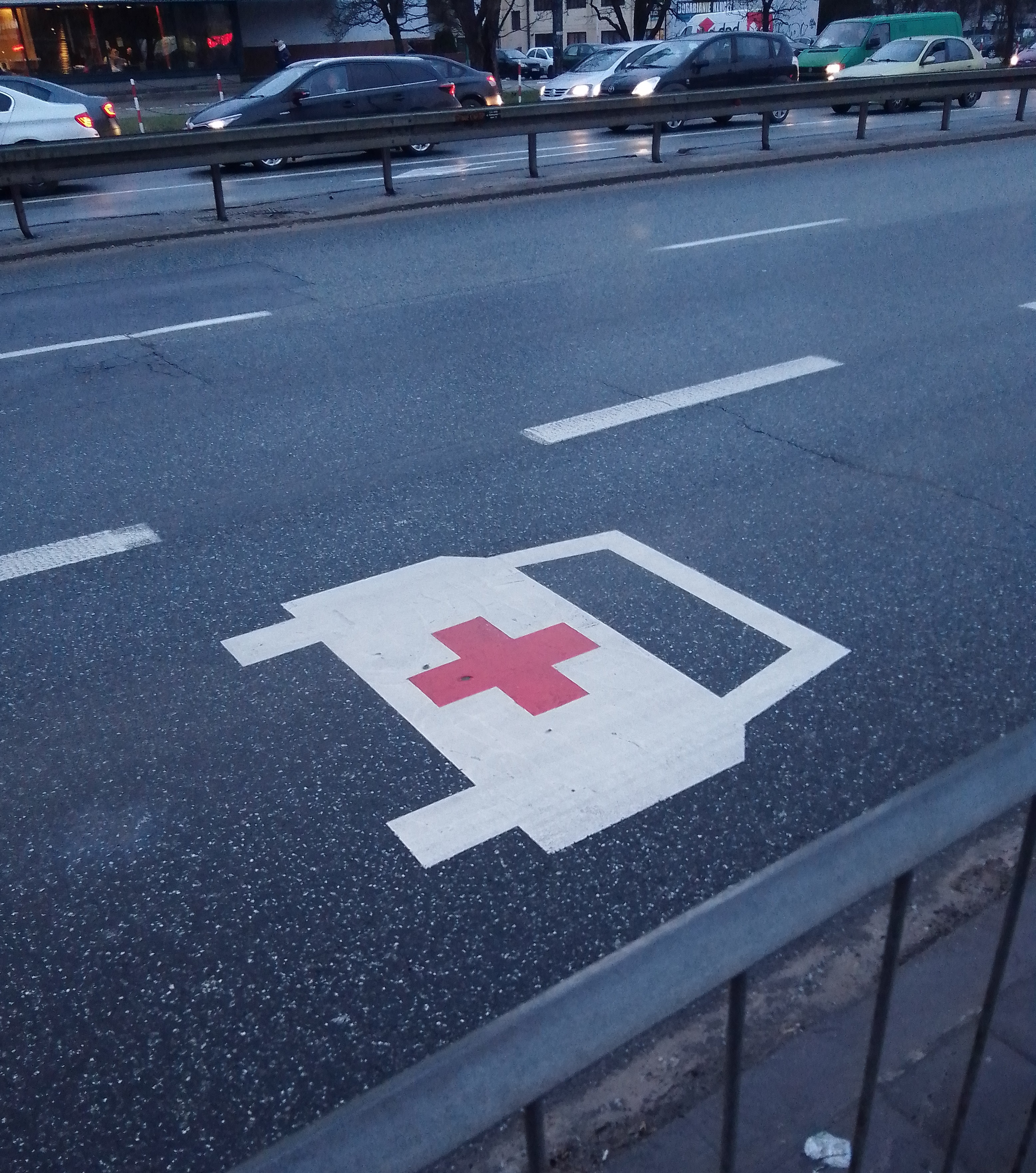
besides being a quaint little roadway, a lane can also be designated for a special purpose, such as for bicycles, buses or emergency vehicles.

Ambulance lane.jpg
Image: CC0, Link


12 October 2022

Why name the Americas "America?"

America is named after Amerigo Vespucci, the Italian explorer. He is the man who set forth what was then considered to be a revolutionary concept: that the lands that Christopher Columbus sailed to in 1492 (but didn't actually land on) were part of a separate continent. 

A map created in 1507 by Martin Waldseemüller was the first to depict this new continent with the name "America," a Latinized version of "Amerigo."

Detail of the Waldseemüller map showing the name "America."
The Library of Congress purchased of the only known extant copy of this map
for $10 million, thanks to the generosity of the U.S. Congress, Discovery Channel, Gerald Lenfest, David Koch and several other donors.

Waldseemüller's large world map included map data that had been gathered by Vespucci during his voyages of 1501-1502 to the New World. he named the new lands "America" on his 1507 map in the recognition of Vespucci's understanding that a new continent had been discovered.

See www.loc.gov/wiseguide/aug03/america.html

26 November 2021

Point Nemo


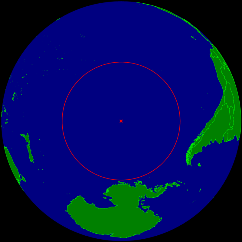
Point Nemo is quite literally in the middle of nowhere. In fact, though it is real, it is nowhere. At least it is not anywhere you can go to live if you want to get away from it all.

Is it a fictional place found in literature? No. It is a point in the Pacific Ocean. It is a spacecraft cemetery. It is the South Pacific Ocean Uninhabited Area. It is an oceanic pole of inaccessibility.

It's not the only one. Other poles of inaccessibility include the Eurasian Pole, in China and the Southern Pole of Inaccessibility in Antarctica.

Point Nemo is in the southern Pacific Ocean east of New Zealand. It has become where spacecraft that have reached the end of their usefulness are routinely de-orbited and destroyed.

It is a good spot to use since it is 2,688km away in every direction, to be precise, to the Pitcairn Islands, Moto Nui in the Easter Islands, and Maher Island in Antarctica.

The name, Point Nemo, might remind you of a certain animated fish, but that is not its origin. It has a double significance. “Nemo” is Latin for “no one” which certainly is appropriate for a place where no one will ever live. It also is an allusion to Jules Verne's submarine Captain Nemo from 20,000 Leagues Under The Sea

Point Nemo is so isolated that the closest people to it are not on any of the nearest landmasses. Astronauts aboard the International Space Station are around 258 miles from their home planet at any given time, so they are the closest people to Point Nemo as they pass over it. The inhabited area closest to Point Nemo is more than 1,000 miles away.

For some more about Point Nemo see One-Page Schoolhouse and an expanded and more personal take on being in the middle of nowhere, check out this at Weekends in Paradelle.

10 August 2018

Countries Ending in -stan

Have you noticed how may countries end with -stan? This suffix comes from the Proto-Indo-European language which was a prehistoric Eurasian language. Linguists have reconstructed it and find it in many language descendants.

In Russian -stan means “settlement.” In other Slavic languages it means “state.” But it is the ancient Indo-Iranian peoples (descendants of Proto-Indo-Europeans who moved east and south from the Eurasian steppe) who used -stan to mean “place” or “place of” that we find in the names of the modern countries.

Urdu and Pashto, the official languages of Pakistan and Afghanistan respectively, both descend from the Indo-Iranian language. Also the former Soviet -stan countries have historically been mostly ethnically Turkic and speak languages from the Turkic family.


So, Afghanistan is the "Land of the Afghans.”

Kazakhstan is the “Land of the Kazakhs” and Kazakh is derived from a Turkic word meaning “independent.”

Kyrgyzstan being the “Land of the Kyrgyz” and Kyrgyz is thought to come from the Turkic word for “forty” being a reference to forty clans that banded together.

Though Pakistan - “Land of the Pure” in Urdu could come from the Indo-Iranian pak, word for “pure/clean”), the country’s name was constructed as an acronym in the 1930s. It referes to the area’s constituent cultures: Punjabi + Afghani + Kashmiri + Sindhi + Balochistan with an "i" inserted to aid pronunciation.

Tajik historically was used by Turks to refer to “non-Turks” that spoke Iranian-related languages, so Tajikistan is the "Land of the Tajiks.”

Turkmenistan is the “Land of the Turkmen.”

Uzbeki+stan rom Uzbek which either comes from Uzbek Khan, a tribal leader who united different groups in the region, or a combination of Turkic words meaning “his own master.”


Source: Mental Floss

26 December 2017

Arctic


The Arctic is a polar region located at the northernmost part of Earth, and it consists of the Arctic Ocean, adjacent seas, and parts of Alaska (United States), Northern Canada (Canada), Finland, Greenland (Denmark), Iceland, Norway, Russia and Sweden.

But interestingly, its name comes from the sky above that predominantly treeless permafrost-containing tundra. The Great Bear Constellation, officially Ursa Major, comes from Latin where it means “greater she-bear.” Go back earlier to the Greek arktos which is the word for bear.


The name Arctic, meaning bearish, describes not only a land of the polar bear but also the parts of the Earth where the Great Bear constellation dominates the heavens even more than in the rest of the Northern Hemisphere.

A very large constellation, Ursa Major is best known for its famous asterism (star grouping) the Big Dipper.

20 March 2017

State Names in the United States part 2


In part 1, I started the stories of the names of the states in the United States of America. This post concludes that list with more origins from the native people, British places, kings, queens, rivers and geography.

NEW HAMPSHIRE was named after the southern English county of Hampshire by Captain John Mason, an early settler who came from that county.

NEW JERSEY My home state was named after the Channel Island of Jersey by Sir George Carteret, who also used the name of his earlier home. Vice Admiral Sir George Carteret, was not an explorer but a royalist statesman. He was Treasurer of the Navy, and one of the original Lords Proprietor of the former British colony of Carolina and New Jersey.  The city of Carteret, New Jersey, as well as Carteret County, North Carolina, are also named after him.

NEW MEXICO or Nuevo México was first used by a seeker of gold mines named Francisco de Ibarra, who explored far to the north of Mexico in 1563 and reported his findings as being in "a New Mexico" hoping that this area would be as rich in resources as the southern area. Juan de Oñate officially established the name when he was appointed the first governor of the new Province of New Mexico in 1598.

NEW YORK was named after the English Duke of York and Albany (and the brother of England's King Charles II) in 1664 when the region that had been called New Amsterdam was taken from the Dutch. The state was a colony of Great Britain until it became independent on July 4, 1776.

NORTH CAROLINA and SOUTH CAROLINA are both named after Charles IX of France.  Carolina is a Latin feminine form of Charles.

NORTH DAKOTA and SOUTH DAKOTA come from "Dakota," a Sioux Indian word for friend or friend alliance. President James Buchanan signed the bill creating the Dakota Territory in 1861 which originally included the area covered today by North and South Dakota as well as Montana and Wyoming. On November 2, 1889, both North and South Dakota were admitted to the Union, becoming the 39th and 40th states.

OHIO originates from the Iroquois Indian word for a "good river." This Indian name was later translated by the French as La Belle Riviere (the Beautiful River).

OKLAHOMA is a word that was made up by the native American missionary Allen Wright. He combined two Choctaw words, "ukla" meaning person and "humá" meaning red to form the word that first appears in a 1866 Choctaw treaty. Oklahoma means "red person."

OREGON's origin is still debated. It is possibly a misreading of the river name in Wisconsin that was written as Ouaricon-sint on an 18th century map, but with the last 4 letters on the next line and therefore dropped. Most scholarship ascribes the earliest known use of the name "Oregon" to a 1765 petition by Major Robert Rogers to the Kingdom of Great Britain, seeking money to finance an expedition in search of the Northwest Passage. The petition read "the rout... is from the Great Lakes towards the Head of the Mississippi, and from thence to the River called by the Indians Ouragon...." After that, the early Oregon Country and the present day state took their names from that river, which is now known as the Columbia River.

PENNSYLVANIA King Charles II of England owed $80,000 to Admiral Sir William Penn. In 1681, as payment for the debt, the king granted what is today Pennsylvania to the admiral's son, who was also named William Penn. Penn named the territory New Wales but also suggested Sylvania (woodland) for his land. Eventually, his name and sylvania were combined to mean "Penn's Woods."

RHODE ISLAND  The first mention of the name Rhode Island or any of its variations in connection with Narragansett Bay is in the letter of Giovanni da Verrazzano, the explorer, dated July 8, 1524, in which he refers to an island near the mouth of Narragansett Bay, and likens the island to the Island of Rhodes in the Aegean Sea.

TENNESSEE In the early 18th century, British traders encountered a Cherokee town named Tanasi (or "Tanase") in present-day Monroe County, Tennessee. The town was located on a river of the same name (now known as the Little Tennessee River), and appears on maps as early as 1725 in its Anglicized spelling of the Cherokee river name.

TEXAS is based on the Caddo word tejas meaning "friends" or "allies", and was applied by the Spanish to the Caddo themselves and to the region of their settlement in East Texas.

UTAH  When the Mormons first came to the territory, they named the area The State of Deseret, a reference to the honeybee in The Book of Mormon  This name was the official name of the colony from 1849 to 1850. The nickname, "The Deseret State," is in reference to Utah's original name. Utah is derived from the name of the native tribe known as the Nuutsiu or Utes (which itself may come from the Apache yudah, yiuta or yuttahih, meaning “they who are higher up”), whom the Spanish first encountered in modern-day Utah in the late 1500s. In the tribe's language, ute means “Land of the Sun.”

VERMONT is an English form of the name that French explorer Samuel de Champlain gave to Vermont's Green Mountains on his 1647 map. He called them "Verd Mont" meaning "green mountain."

VIRGINIA and WEST VIRGINIA were both named to honor Elizabeth I, the Virgin Queen.

WASHINGTON  was named after George Washington, the first President of the United States. The state was made out of the western part of the Washington Territory, which had been ceded by Britain in 1846 in accordance with the Oregon Treaty in the settlement of the Oregon boundary dispute.

WISCONSIN was originally "Meskonsing" and is the English spelling of a French version of a Miami Indian name for a river that runs 430 miles through the center of the state and is now known as the Wisconsin River. At one time the word was translated as meaning "long river," but recent scholarship has concluded that in Miami it meant, "this stream meanders through something red" and that is was a reference to the red sandstone bluffs of the Wisconsin Dells.

WYOMING is thought to be a contraction of the Native American word mecheweamiing  meaning "at the big plains" and was first used by the Delaware people as a name for the Wyoming Valley in northeastern Pennsylvania.

28 November 2016

State Names in the United States part 1

The names of the 50 states in the United States of America come from different origins.  As you can see below, some come from the explorers, discoverers and the conquerors and those who ruled over an area. Likewise, British kings, queens and noblemen had their names used for areas that are now states. These are largely the sources for much of the east coast that was first explored. As expansion moved west, Anglicized versions of Indian words and the names used by the native people of an area became a common source of state names.

CALIFORNIA is an invented name for an imaginary island, but the explorer Cortes is said to have transferred the name to the area we know as the state.

COLORADO comes from Spanish, meaning reddish, and was applied by Spanish explorers to the area surrounding what is now the Colorado River for its reddish color.

CONNECTICUT is an Algonquian word meaning "long river." The second "c" has never really been used in pronunciation.

DELAWARE is named for Thomas West, Lord de la Warr, an English politician, for whom the bay, the river, later, a Native American people and the U.S. state all got their names.

FLORIDA is from Spanish, meaning the land of flowers.

All of these state names have more complicated origins. For example, the first European contact with Florida was made in 1513 by Spanish explorer Juan Ponce de León.He named it La Florida but his landing was during the Easter season of  Pascua Florida. Pascua Florida is a Spanish term that means flowery festival or feast of flowers and it is connected to the Easter season and the Passion of the Christ. Pascua can, depending on context, refer to Easter, Christmas, Epiphany, Pentecost, or the week after holy week. Pascua Florida Day is usually celebrated on April 2, the day on which Ponce de León first spotted Florida.

GEORGIA was named to honor King George II.

HAWAII is the name of the state's largest island, Hawaiʻi. One Hawaiian explanation of the name Hawaiʻi is that it comes from Hawaiʻiloa, a legendary figure from Hawaiian myth who was said to have discovered the islands when they were first settled, and it is sometimes translated as "place of the gods."

IDAHO is often said to be an Indian word, but its origin is more complicated. When the United States Congress was considering designating a new territory in the Rocky Mountains, a lobbyist George M. Willing suggested the name "Idaho", which he claimed was derived from the Shoshone "ee-da-how" meaning "the sun comes from the mountains" or "gem of the mountains."  Willing later claimed that he had simply invented the name.  Congress in 1861 decided to name the area "Colorado Territory" but the Idaho name lingered. A community in Colorado was named "Idaho Springs" and in 1861 an Idaho County was created in eastern Washington Territory after a steamship named Idaho, which was launched on the Columbia River in 1860. A portion of Washington Territory, including Idaho County, was used to create Idaho Territory in 1863.

Besides the Shoshone term, there is some evidence that it may be derived from the Plains Apache word "ídaahę́", which means "enemy" and that the Comanches used this word to refer to the area that became the Idaho Territory.

ILLINOIS - Though some sources say this is an Algonquian word meaning "men and warriors," the most recent explanation is that "Illinois" is the modern spelling for the early French Catholic missionaries and explorers' name for the Illinois Native Americans, though the name was spelled in many different ways in the early records.

INDIANA was meant as a way of designating the "Land of the Indians" when Congress passed legislation to divide the Northwest Territory into two areas. The western section was the Indiana Territory.

IOWA derives its name from the Ioway people, one of the Native American tribes that occupied the state at the time of European exploration

KANSAS is another state named for the natives who inhabited the area originally. In this case, it was the Kansa tribe. The tribe's name (natively kką:ze) is said to mean "people of the wind" or "people of the south wind", although this was probably not the term's original meaning.

KENTUCKY is probably based on an Iroquoian name meaning "(on) the meadow" or "(on) the prairie" (cf. Mohawk kenhtà:ke, Seneca gëdá’geh. Prior to 1776 when the counties of Virginia beyond the Appalachian Mountains became known as Kentucky County, the Kentucky River already carried the name.

LOUISIANA was named after Louis XIV, King of France from 1643 to 1715. When René-Robert Cavelier, Sieur de La Salle claimed the territory drained by the Mississippi River for France, he named it La Louisiane. The suffix -ana or -ane is a Latin suffix that can refer to "information relating to a particular individual, subject, or place." Thus, roughly, Louis + ana carries the idea of "related to Louis." The Louisiana Territory was very large and once part of the French Colonial Empire and stretched from present-day Mobile Bay all the way to just north of the present-day Canada–United States border including a small part of what is now southwestern Canada.  French: État de Louisiane and Louisiana Creole: Léta de la Lwizyàn.

MAINE or French État du Maine - The etymology is not definitively explained but the most common origin story is that it was the name given by early explorers after a province in France. The word refer to "mainland." By 1665, when the English King's Commissioners ordered that the "Province of Maine" be entered in official records. The state legislature in 2001 adopted a resolution establishing Franco-American Day, which stated that the state was named after the former French province of Maine.

MARYLAND which is nicknamed Old Line State, the Free State, and the Chesapeake Bay State is named after Henrietta Maria of France, the wife of Charles I of England.

MASSACHUSETTS prior to being a state was the Massachusetts Bay Colony. The name came from the indigenous people of that area, the Massachusett. The name can be segmented as mass/large, adchu/hill, s (diminutive suffix meaning "small") and -et a locative suffix that identifies it as a place. It has been variously translated as "near the great hill","by the blue hills", "at the little big hill", or "at the range of hills." The Great Blue Hill is located on the boundary of Milton and Canton. An alternative origin is from the spelling Moswetuset, from the name of the Moswetuset Hummock (meaning "hill shaped like an arrowhead") in Quincy where Plymouth Colony commander Miles Standish and Squanto, part of the now disappeared Patuxet band of the Wampanoag peoples, met Chief Chickatawbut in 1621.

The official name of the state is the "Commonwealth of Massachusetts" and it is sometimes referred to as "the Commonwealth" an, although this designation is part of the state's official name, Massachusetts has the same position and powers within the United States as all the other states.

MICHIGAN has a complicated history of French and Indian occupation. The closest translation for the state seems to be an Algonquian word translating to "big lake" or "forest clearing." The French had Fort Michilimackinac at the Straits of Mackinac to better control their lucrative fur-trading empire. Michigan is the only state to consist of two peninsulas. The Lower Peninsula, to which the name Michigan was originally applied, is separated from the Upper Peninsula by the Straits of Mackinac, a channel that joins Lake Huron to Lake Michigan. The two peninsulas are connected by the Mackinac Bridge.

MINNESOTA comes from the Dakota Sioux name for the Minnesota River. It comes from either 'Mnisota' which means "clear blue water", or 'Mnißota', which means cloudy water. Supposedly, the Native Americans demonstrated the name to early settlers by dropping milk into water and calling it mnisota. Many places in the state have similar names, such as Minnehaha Falls ("laughing water" (waterfall)), Minneiska ("white water"), Minneota ("much water"), Minnetonka ("big water"), Minnetrista ("crooked water"), and Minneapolis, a combination of mni and polis, the Greek word for "city."

MISSISSIPPI The name of the state is derived from the Mississippi River, which flows along its western boundary. Settlers named it after the Ojibwe word misi-ziibi meaning "Great River."

MISSOURI is another state named for a river. The Missouri River was named after the indigenous Missouri Indians, a Siouan-language tribe. They were called the Ouemessourita meaning "those who have dugout canoes", by the Miami-Illinois language speakers. As the Illini were the first natives encountered by Europeans in the region, the latter adopted the Illini name for the Missouri people.

MONTANA comes from the Spanish word Montaña and the Latin word Montana, meaning "mountain", or more broadly, "mountainous country." Montaña del Norte was the name given by early Spanish explorers to the entire mountainous region of the west

NEBRASKA is derived from transliteration of the archaic Otoe Sioux words Ñí Brásge meaning "flat water" after the Platte River that flows through the state.

NEVADA is directly taken from the Spanish nevada  meaning "snow-covered" because of the Sierra Nevada ("snow-covered mountain range").

10 October 2016

Amazon

The Amazon.com home page in 1999

Amazon.com, also known simply as Amazon, was founded in 1994 by Jeff Bezos.

Bezos incorporated the company as "Cadabra" in 1994 as a play on the "magical" incantation "abracadabra." A year later, he changed the name because he was told it was heard as "cadaver" and a dead body is not a good association for a company.

Bezos also bought the domain relentless.com for possible use, but was told by friends it soiunded too sinister. and briefly considered naming his online store Relentless, but friends told him the name sounded a bit sinister.

The company went online as Amazon.com in 1995.

Bezos selected the name Amazon in a dictionary search wanting an "A" name that would be high on an alphabetized list (an old print phone book idea) and because the Amazon river was by far the "biggest" river in the world, and it matched his goal to be the biggest store in the world. The current logo features a curved "smile arrow" leading from A to Z, representing that the company carries every product from A to Z.

The Amazon River (originally called Río Santa María del Mar Dulce, or Mar Dulce, "sweet sea" because of its fresh water pushing out into the ocean) took on its current name from another Spanish explorer, Francisco de Orellana. He was the first European man to travel from the river's sources in the Andes to the end of the river. He used the name Amazonas because the natives that attacked his expedition were mostly women and he was reminded of the woman warriors, the Amazons, from Hellenic culture. The Amazons were real Scythian women who fought and later were mythologized by the Greeks.

24 June 2015

kill (body of water)

Looking across the Arthur Kill from Perth Amboy, NJ to Harbortown, NY

I was reading an article about my home area of New York / New Jersey and it alluded to a body of water known as the Arthur Kill. I've seen the term before and never really questioned it, knowing it as simply some kind of waterway.

A kill is similar to a creek. The word comes from the Middle Dutch kille, meaning "riverbed" or "water channel". It is logical then that we find the term used in areas of Dutch influence.

You will find it used to describe waterways in the Delaware and Hudson Valleys and other areas of the former New Netherland colony of Dutch America. Beside the Arthur Kill (separating NJ from NY's Staten Island), you find the Kill Van Kull, Dutch Kills and English Kills off Newtown Creek, Bronx Kill between the Bronx and Randalls Island.

It also shows up in names of rivers - the Wallkill River in New York and New Jersey and the Schuylkill River in Pennsylvania, and in Delaware the spooky-sounding Murderkill River, the Broadkill River, and a river made for a mystery story, the Whorekill River.

The word can't quite escape its English murder and death  association. For example, beside the Arthur Kill is a place known as the "Graveyard of Ships."

The Fresh Kills waterway goes to what was formerly the Fresh Kills landfill. Twenty years ago, it had the dubious honor of being the largest landfill in the world.

The term "kill" is also used in some geographic places and towns: the Catskill Mountains, the city of Peekskill, the town of Fishkill, New York, and the hamlet of Wynantskill, New York.

Arthur Kill area - NJ to the left

23 December 2010

Stonehenge


Stonehenge always gets a little extra attention at a solstice.

Stonehenge is a prehistoric monument located in the English county of Wiltshire, about 13 kilometres (8.1 mi) north of Salisbury. It is one of the most famous sites in the world.

Stonehenge is composed of earthworks surrounding a circular setting of large standing stones. It is actually the center of a complex of Neolithic and Bronze Age monuments.

Solving Stonehenge: The Key to an Ancient EnigmaArchaeologists had believed that the iconic stone monument was erected around 2500 BC. The complex included a large timber circle and a second avenue that were constructed 3.2 kilometres (2.0 mi) away at Durrington Walls overlooking the River Avon.

This timber circle was orientated towards the rising sun on the winter solstice and opposing the solar alignments at Stonehenge. The "avenue" was aligned with the setting sun on the summer solstice and led from the river to the timber circle.

Stonehenge Complete, Third EditionEvidence has been found of huge fires that were burned on the banks of the Avon between the two avenues. This suggests to researchers that these two circles were linked. This may have been a processional route on the longest and shortest days of the year.

Michael Parker Pearson speculates that the wooden circle at Durrington Walls was the center of a "land of the living" and that the the stone circle at Stonehenge represented a "land of the dead."

The Oxford English Dictionary cites Ælfric's 10th-century glossary, in which henge-cliff is given the meaning "precipice", a hanging or supported stone.

So, the stanenges or Stanheng "not far from Salisbury" recorded by 11th-century writers are  the "supported stones".

The origin of this place name is probably from the Old English words stān meaning "stone", and either hencg meaning "hinge" (because the stone lintels hinge on the upright stones) or hen(c)en meaning "hang" or "gallows" since the stones look like the medieval gallows with two uprights with a lintel joining them (as opposed to the modern inverted L gallows we would draw).

Photo and Information: http://stonehengenews.wordpress.com
More information:
http://en.wikipedia.org/wiki/Stonehenge 
Stonehenge Complete
A Brief History of Stonehenge
If Stones Could Speak: Unlocking the Secrets of Stonehenge (for kids)
Solving Stonehenge: The Key to an Ancient Enigma  

Video:
Stonehenge Decoded
Nova: Secrets of Stonehenge

30 June 2010

Street Names Using First Names


I stumbled upon this very cool mashup of data and maps on http://www.weathersealed.com that has aggregated data on street names that are actually people's first names. It seemed like a natural for this blog.

The results are organized alphabetically by gender and pinpoint North American roads that share 2000+ common boy and girl first names.

Click the links below to view a list of names. The places are viewable with Google Maps (use the number link) or, even better, the free Google Earth.

I found a surprising 465 Kenneth streets including a bunch in my home state.

Of course, not every name has a street, and they kicked out some data (like street names that contain "unrelated gobbledygook" such as the “Little” in “Little John Street”). Their data came from the Social Security Administration and street information from the Open Street Map project.

The information is available under the Creative Commons Attribution-ShareAlike 2.0 license.

Go to the BOYS' STREET NAMES

Go to GIRLS' STREET NAMES

25 May 2010

Arizona

Arizona Highways Photography Guide: How & Where to Make Great Pictures (Arizona Highways: Travel Arizona Collection)   Arizona: A History  Arizona State Flag, Nylon (3 ft. x 5 ft.)

Arizona is a state of the United States of America located in the southwestern region of the United States. The capital and largest city is Phoenix. Arizona is the 48th state and last of the contiguous states admitted to the Union, achieving statehood on February 14, 1912.

Arizona is one of the Four Corners states. It borders New Mexico, Utah, Nevada, California, touches Colorado, and has a 389-mile (626 km) international border with the states of Sonora and Baja California in Mexico. It is the largest landlocked U.S. state by population. In addition to the Grand Canyon, many other national forests, parks, monuments, and Indian reservations are located in the state.


The etymology of the name "Arizona" is not clearly fixed on one explanation. Historians note the Basque phrase aritz ona, "good oak, although the O'odham phrase alĭ ṣonak, "small spring" is also considered a possibility.

The name "Arizonac" was initially applied to the area near the silver mining camp of Planchas de Plata, Sonora, and later, in its shortened form of Arizona, it was applied to the entire territory.

Marcos de Niza, a Spanish Franciscan, explored the area in 1539 and met its original native inhabitants, probably the Sobaipuri. The expedition of Spanish explorer Coronado entered the area in 1540–42 during its search for Cíbola.

When Mexico achieved its independence from Spain in 1821, what is now Arizona became part of the Mexican Territory Nueva California, also known as Alta California.

In the Mexican–American War (1847), the U.S. occupied Mexico City and forced the newly founded Mexican Republic to give up its northern territories, including what later became Arizona. The Treaty of Guadalupe Hidalgo (1848) specified that the sum of $15 million US dollars in compensation be paid to the newly formed Republic of Mexico.

Arizona was administered as part of the Territory of New Mexico until southern New Mexico seceded from the Union as the Confederate Territory of Arizona on March 16, 1861. Arizona was recognized as a Confederate Territory by presidential proclamation of Jefferson Davis on February 12, 1862 and this is the first official use of the name.

A new Arizona Territory, consisting of the western half of New Mexico Territory was declared in Washington, D.C., on February 24, 1863.

Other names including "Gadsonia", "Pimeria", "Montezuma", "Arizuma", and "Arizonia" had been considered for the territory. However, when President Lincoln signed the final bill, it read "Arizona", and the name became permanent.

Arizona: A History
Frommer's Arizona 2010
Backroads of Arizona Guide to Arizona's Most Scenic Backroad Adventures
Arizona Highways Photography Guide

13 May 2010

Alabama

Many of the 50 states in the United States have names that are derived from the native peoples who lived in that area and from the explorers that "rediscovered" and settled the area.

Alabama is a state located in the southeastern region of the United States of America. It is bordered by Tennessee to the north, Georgia to the east, Florida and the Gulf of Mexico to the south, and Mississippi to the west. Alabama ranks 30th in total land area and ranks second in the size of its inland waterways. The state ranks 23rd in population with almost 4.6 million residents in 2006.

The Alabama, a Muskogean tribe whose members lived just below the confluence of the Coosa and Tallapoosa Rivers on the upper reaches of the Alabama River, are the etymological source of the names of the river and state.

The word Alabama is believed to have originated from the Choctaw language and was later adopted by the Alabama tribe as their name.

The spelling of the word varies depending on the source. The first usage appears in three accounts of the Hernando de Soto expedition of 1540 as "Alibamo."

As early as 1702, the tribe was known to the French as Alibamon with French maps identifying the river as Rivière des Alibamons.

Though the origin of Alabama seems clear, the actual meaning of the tribe's name. It is generally accepted that the word comes from the Choctaw words alba (meaning "plants" or "weeds") and amo (meaning "to cut", "to trim", or "to gather"). Therefore, translations can be "clearers of the thicket" or "herb gatherers" referring to clearing of land for the purpose of planting crops or to collection of medicinal plants by medicine men.

Alabama history
Alabama: The History of a Deep South State

12 May 2010

Alaska


Alaska

Alaska is the largest state of the United States by area. It is situated in the northwest extremity of the North American continent, with Canada to the east, the Arctic Ocean to the north, and the Pacific Ocean to the west and south, with Russia further west across the Bering Strait. As of 2009, Alaska remains the least densely populated state of the U.S.

The U.S. Senate approved the purchase of Alaska from the Russian Empire in 1867, for $7.2 million at about two cents per acre. The land went through several administrative changes before becoming an organized territory on May 11, 1912, and the 49th state of the U.S. on January 3, 1959.

The name "Alaska" (Аляска) was already introduced in the Russian colonial time, when it was used only for the peninsula and is derived from the Aleut alaxsxaq, meaning "the mainland" or more literally, "the object towards which the action of the sea is directed".  It is also known as Alyeska, the "great land" which is an Aleut word derived from the same root.

The Frozen Toe Guide to Real Alaskan Livin'
Alaska: Into the Wilderness
Alaska: A Novel
Alaska (Eyewitness Travel Guides)
Alaska travel books
Gourmet Food from Alaska
Alaska Smokehouse Smoked Salmon Fillet in Wood Gift Box, Assorted Designs, 4-Ounce Each (Pack of 4)